Title: Supercell Left Flank Boundary Dynamics
Authors: Mark De Bruin, Adam Houston (University of Nebraska-Lincoln)
Abstract:
Supercell internal boundaries are the locus of tornadogenesis; thus, understanding the characteristics of these boundaries, particularly in terms of vorticity, is important for identifying the role they play in tornado formation. Insight into the overall characteristics of internal boundaries and their possible role in tornadogenesis have been driven by studies reliant on numerical modeling-based experiments. Observational studies often neglect above-surface conditions or, when these observations are made, lack the spatial resolution to resolve boundary characteristics. During TORUS (Targeted Observation by Radars and UAS of Supercells) 2019 and TORUS-LItE (TORUS Left-flank Intensive Experiment) 2023, uncrewed aircraft systems (UAS) and mobile mesonets collected in situ kinematic and thermodynamic observations across left and forward flank boundaries. Three TORUS and TORUS-LItE cases are analyzed herein with the goal of updating understanding of supercell internal boundaries . This analysis reveals that the strongest near-surface vertical vorticity is typically collocated with enhanced streamwise vorticity, baroclinic generation, and gradients in vertical motion and equivalent potential temperature. Horizontal gradients in vertical motion distributed over scales of several hundreds of meters are present in all three cases and made appreciable contributions to horizontal vorticity. Analysis of the 26 May 2023 case reveals a likely streamwise vorticity current (SVC) embedded in the head of a density current-like feature. Comparable structures are observed in the left flank boundaries of the 11 June 2019 case, but with differences in cold pool shape and pressure perturbations. In fact, lack of a meaningful pressure jump in the 26 May 2023 and 12 June 2023 cases are the primary reason the boundaries in these cases cannot be classified as a true gust front.
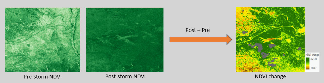
The Automated Assessment of Hail Swaths
Authors: Mark De Bruin, Phil Schumacher (NWS/CIRA), Kevin Gallo (NESDIS/retired)
Description:
Supercells that produce large, wind-driven-hailstones cause millions of dollars in damage annually in the United States
to structures and crops, often in long swaths. Because most hail reports are at a single point, supercell hail swaths are
often spatially underestimated.
We can identify hail swaths using:
- GOES-16 Advanced Baseline Imager (ABI) data
- The US Department of Agriculture Crop Data Layer (CDL)
- Multi-radar multi-sensor (MRMS) maximum estimated size of hail (MESH).
This process previously involved manual GOES data downloads and multiple R or python scripts, all of which add up to hours
of time for a single case. We have developed a program that within minutes will generate NDVI difference maps, isolate hail swaths,
and download additional data like local storm reports (LSRs) and severe thunderstorm warnings. This program was designed for the
National Weather Service to assist in identifying hail swaths by supplementing limited LSR availability.
Physical Mechanisms Behind Tornado Outbreak Location During the 15 December 2021 Quasi-Linear Convective System
Authors: Mark De Bruin, William Gallus (Iowa State University)
Abstract:
One of the most anomalous severe weather events in United States history occurred on 15 December 2021, with a variety of extreme and out-of-season impacts across the Midwest and Great Plains. One of these impacts was the over 100 recorded tornadoes associated with a serial derecho that spanned hundreds of miles. 21 EF-2 tornadoes were produced by the storm in a relatively small section of northwest Iowa, while a section of the derecho further south did not produce any. In this study, we examine mesoscale differences in relevant atmospheric conditions between the northern (tornadic) and southern (non-tornadic) environments. Convective Available Potential Energy, shear magnitudes, and low-level shear orientation to the squall line are examples of crucial parameters that were analyzed. Some differences were found in thermodynamic conditions, but because these differences were insufficient to explain the drastically different outcomes in tornadic activity, storm behavior was also examined as a cause using radar data. Storm-scale factors like the bow apex, line orientation, and downdraft surges were found to be likely influences. Results from this research both affirm the complexity of forecasting Quasi-Linear Convective System (QLCS) tornadogenesis as well as provide additional confidence in the implications of QLCS orientation with respect to the shear profile and its resulting effect on tornadogenesis.
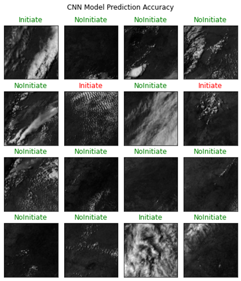
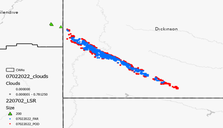
Forecasting Dryline Convective Initiation with Machine Learning
Authors: Mark De Bruin
Description:
When it comes to forecasting severe weather impacts, dryline boundaries are often the forcing mechanism by which strong supercells may form. A situation is posed by a strong dryline where two likely scenarios are blue skies and mild weather or supercell initiation and severe impacts. Could a properly trained machine learning algorithm perform better than a human forecaster at recognizing patterns in satellite imagery that would indicate the likelihood of convective initiation? This class project uses a dataset of dryline events and corresponding GOES-16 ABI imagery (including visible, infrared, and water vapor channels) as the training dataset for a convolutional neural network (CNN) to predict convective initiation in the following several hours. The image below shows the model predictions and verification for several of the dryline images in the testing dataset (green is a correct forecast, text is the truth).